For our last day in Utah, we visited the famed Four Corners site, where Utah, Arizona, New Mexico, and Colorado all meet. Brooke had been there before, so she kinda knew what to expect. It was a nice facility, with different vendors in booths a la a farmer’s market selling things ranging from shirts and magnets to hand-made jewelry, knives, and arrows.
There wasn’t much of a line, thankfully, so we got our obligatory pictures, did a little shopping, and then got a snack before heading out.
We knew we wanted to do something else that Thursday afternoon, and my vote was more hiking (since we really hadn’t done much….). The downside is that it was 108 F outside (the car said 113 F….eeeeeesh….), so we wanted to limit the mileage a bit.
We searched around for trails and came across one that was about a mile out toward a cave. We had to go off-roading a bit to get to this site, so that provided a little adventure, but at least it wasn’t the hours of “off the beaten path” we did a few days prior.
You can see the cave off in the distance, and we thought, “hey, that doesn’t look too far!” Turns out it would be harder than we thought!
We parked near the main road, unsure of what our options would be further down, so we left the car and walked down a road until it hit the trail. It started out fine, but it was pretty sandy and there wasn’t much shade, unfortunately. There were bits, but there were long stretches of none, which was pretty draining.
We did see some outcroppings with what looked as if they used to be dwellings, but they weren’t preserved, so there wasn’t a lot to see. Given the heat, and the fact there weren’t really trails heading toward spots like this, we mostly looked and then kept going.
By the time we got to our destination, we saw a relatively steep slick rock face heading up to the cave entrance, and given our potential for heat exhaustion, Brooke and Meg hung back to have some water in a shady spot while I proceeded to get a better look. This image is with the telephoto, so I didn’t get nearly this close, but it was enough to see that it looked pretty cool! There was a lot of vegetation between the slick rock and the cave, though….and it was very hot….so I took a few pictures and went back down. Calvin came part of the way up the hill with me, but by then, we were getting a bit concerned about his condition.
Brooke and Meg walked back and I hung out with Calvin in the shade a bit. He looked like he was overheating, so he cooled off a bit, drank some water, and when he was ready, we kept going. He was taking it a bit slower, but I don’t think it was anything really serious. It was hot and he’s small: simple as that.
That night, we had dinner and stayed up late to watch the sunset outside of town. We were hoping to see the Milky Way, but we probably would have had to wait a lot longer and none of us were really in the mood to stay up. It was nice to experience the stars away from pesky lights in town, though, and it was cool to be in the middle of literally nowhere!
After that, it was time to head home on Friday! We went through southern Colorado this time, so it was a different route through the Rockies. We stopped for lunch up in the mountains (Brooke made sandwiches) next to a river, which is always a lovely experience. We stopped in Garden City, KS for dinner that night at a nice Mexican restaurant, and then drove another hour-ish to Dodge City, KS for the night. Similar to our trip out west in the first place, we put in a lot of hours on that Friday so that we would get home at a reasonable time on Saturday afternoon.
In the end, we drove 3151 miles on this trip, which was a little over half what we did when we drove the Pacific Coast Highway.
We’re in an interesting “spot,” so far as our next vacation goes. Brooke and I have our 20th wedding anniversary next year, so we’ll do a trip by ourselves, but we will still need to do something with the kids (….I mean…I guess we need to??), so it may be “expensive trip” for the two of us and “shorter/cheaper trip” for the four of us. We’ll see!
We had reservations for Mesa Verde National Park on Tuesday of our vacation, so this was kinda the one day we really had “locked in” so far as flexibility with everything else went. Brooke had been there before, but it had been many years. She knew generally what to expect, and she’d been on the main tour, Cliff Palace, previously. She really wanted to go to Square Tower house, as that was the most “exclusive,” difficult to attend, tour. The only way to do it was to secure reservations up to 2 weeks in advance, with 10 slots opening at 9:00 am CDT. Two weeks ahead, I sit at my computer, refresh the page at exactly 9:00 am, and within, no joke, 20 seconds, all 10 reservations were taken. Ug. The next day, I tried again, but this time, I actually got to the CAPTCHA verification. It put me through three rounds of verification (motorcycle, bus, crosswalk….)….and then it still didn’t give me any tickets…. Ug ug.
After that, we gave up and went with Balcony House, which wasn’t the main tour everyone does, but it wasn’t the most exclusive one, either. Alas, it would be fine.
Regardless, we made the drive from Blanding to Mesa Verde (an hour and a half-ish), taking a somewhat scenic route through reservation lands, before hitting their impressive-looking visitor center. We didn’t stay long, as we wanted lunch and we were going to do a driving tour of the area.
I should also note that the drive from the visitor center to where the towers are was kinda long? We had to drive up to the top of Mesa Verde, which wasn’t a trivial drive, taking another 30-45 minutes to complete. It was really pretty, though, and surprisingly lush up there (hence where the “verde” name comes in).
One of the neat things about the site is that there are kivas all over the place, but along the driving tour, they were laid out chronologically, so we got to see an older version of one, then a newer one, then a much more ornate one, giving us a sense of how they evolved over generations. The National Park Service also has them covered to protect them from the elements, while also providing shade for tourists like us.
Here’s the view of Cliff Palace from across the canyon, complete with a tour group checking things out. They are truly remarkable structures to see up close, let alone in the distance. One wonders how the residents of these structures got down and up all the time, as the would be farming on the top of the mesa, then returning down to the dwellings in the rock face.
The Balcony House tour took off from a parking lot above the dwelling and, while it wasn’t a strenuous trip down, it wasn’t necessarily simple, either. It took about 10 minutes to get down there, down a paved path, first, then down some metal stairs to a walkway that went alongside the mesa.
The tour guide said he has had people “freak out” due to heights while being down there, so he told everyone that it’s probably not a good idea to go if you think you’re going to run into issues. He said someone had to be airlifted out because they couldn’t be carried from the site below.
Now, I’m not a huge fan of heights, personally, but I thought this was fine. It was far from the edge and there were plenty of railings. Not a big deal. However, there was a spot later on where, if I were much bigger than I am, I would have struggled to get through.
We climbed a ladder to get up to the cliff dwelling, two-by-two, which again is something some folks have problems with. Not a big deal for any of us, though. Kinda neat to get to a tourist site, though!
Once we were up there (also, after kids and adults asked way too many questions, like, right before climbing the ladder! Seriously, hold up with the questions until we’re up there!), the tour guide started pointing out the various structures and some key aspects of the architecture. For example, wooden beams made differently than one another, suggesting that one structure was built first, and then they made changes before the next one. Another kid noticed that each room was labeled a bit differently. The tour guide noted that archaeologists label sites they have investigated in different ways, so it was probably one person “numbering” rooms, and another person came through and “lettered” them, instead. There were multiple architectural anecdotes like that as we continued on.
And at the end, we still see another enormous kiva, deep into the rock. How they dug into the rock face this far is unclear, though it was probably chipping away at rocks for years. This kiva was relatively deep, and it would have had a thatched roof for people to walk across on top. Couldn’t really beat the view from up there, either!
The return trip to leave went through a small tunnel. The tunnel was 18 in wide by 27 in tall, so yeah: small. And it was about 12 ft long. I had my backpack on, so it would have been easier on me if I didn’t… The kids and Brooke didn’t have any issues, but I suspect folks like my father-in-law wouldn’t be all that comfortable trying to climb through.
After that, we headed back to Blanding! Mesa Verde was pretty cool! In some ways, it was kind of like Shenandoah National Park, which we visited last year, where a lot of the trip was driving to and from the park, and driving within the park. Unlike Shenandoah, though, we got to take much longer breaks to see things like Balcony House, or the other kivas along the driving tour.
The following day was spent in Blanding, doing nothing! We had spent a lot of time driving and sightseeing, so we built in a day midweek where nothing was really planned. We watched some “Psych,” we played some cards, we read books – it was a good time to get some relaxing in before our last day before heading home!
The next day, we headed toward Canyonlands National Park, which is just south of Moab, UT. On the way in, we stopped at Newspaper Rock, which is a petroglyph site with drawings dating back at least 1500 years. Like many other petroglyphs and dwellings in the region, these were drawn under a rock face, which has protected the drawings for that period of time.
Other than the petroglyphs, there wasn’t much else to see, so it was a quick stop on our way into Canyonlands!
I should note, since I didn’t earlier, but Calvin happened to be done with 4th grade during this trip. The National Park Service offers the Every Kid Outdoors pass, which allows kids during their 4th grade year (and the summer after!) access to national park lands….for free! …and their families! So yeah, we got to go to Natural Bridges, Canyonlands, and Mesa Verde without having to pay an access fee. We saved at least $150 by taking advantage of it, so thanks for being the right age for this trip, Calvin!
We stopped at the visitor center first, which I’ve been to a number of times going to Utah for our Field Biology course the past few years. I am used to going on longer hikes in this particular park, but the kids weren’t really excited about it, so we opted for shorter trips. One of them was a 1 mile hike that featured flat rock hiking, a few ladders to climb, and some old timey cowboy encampments that illustrated how ranchers used to use the overhanging rocks for shelter.
It was neat to see just how far some of the overhangs went back, like the picture above. It was tall enough that putting horses in there wouldn’t have been an issue, so it’s no wonder ranchers used spaces like these for years. Above, Calvin is standing in front of a spring, where water slowly leached through from the surface above when it rained, again showing the utility of these spaces.
A lot of the hiking in this region is called “flat rock,” which is just as it sounds: walking over flat surfaces rather than on gravel or sand. Due to the Field Biology class I’ve helped out with, I’ve hit a bunch of areas like this, but in Canyonlands, flat rock hiking like this is pretty common. You end up having to find cairns, which are small piles of rocks that indicate the direction of the trail. Since there’s no soil, there’s no way to place a sign telling hikers where to go, so cairns are the norm.
The section of Canyonlands we were in was called the Needles District. There is a really good loop trail that takes you right up to the “needles,” or the rock formations behind us in this picture. That trail is over 10 miles long, though, so we didn’t push it. Next time, hopefully!
Like I said, I’ve gone to this area a few times with our Field Biology course and usually we stay on Bureau of Land Management (BLM) lands. We camp, of course, but you can pitch a tent for free on publicly managed spaces, like those near Canyonlands.
I got the bright idea to go find one of our campsites with the family after we were done at the national park so they could see where I’ve been sleeping, out in the middle of nowhere. However, as evidenced by the picture above, there had been enough rain recently that the road was covered by water. Could the Outback have made it through the puddle? Probably. Did we really want to risk that? Uh, no. So we didn’t. Next time!
We hit Canyonlands that morning, so the plan was to visit Moab, UT for the afternoon. We took in a late lunch at Moab Brewery and picked up some beer to take back with us, including a growler. We didn’t eat until 1:30 pm that day, so given the anticipation, we were all pretty happy with it.
We walked around Moab looking for souvenirs afterwards and mostly struck out. A lot of the shirts, for example, were representing Moab itself or Arches National Park (which is practically in Moab…), which we weren’t visiting, so nothing really jumped out at us.
There were a lot of folks in Moab, though, but we noted that a lot of them seemed like fellow travelers, or otherwise people who were “living the life of the southwest.” Brooke had been to Moab before, but she made it sound like the “Moab” of her childhood is long gone, instead replaced with a much more commercialized town made up of tourists moreso than folks who actually live there.
After we were done in Moab, we headed back to Blanding for the night! Onward to Mesa Verde the next day!
I’ve been down in southeast Utah a few times in the past two years, and Brooke was down here for family vacations and for her 8th grade “LEAP” experience to Crow Canyon Archaeological Center. My family never ventured this far for vacations, so Brooke has a bit more of a “connection” to the region. Thus, it’s always been on the list for our own family to someday visit.
There are multiple reasons to visit this area. For one, the desert environment is pretty foreign compared to what we’re used to in Missouri. Secondly, depending on when you go, the “dry heat” effect means that 90 F is still remarkably pleasant compared to the same temperature in Missouri. This time of year, the evenings are in the high-50s/low-60s, so it cools off right as the sun goes down. Not bad!
The are also a lot of outdoor adventuring activities to consider, especially around Moab, UT, where you can rent off-road vehicles and you’ll see countless trailers and camper vans to be jealous of.
And finally, there’s the Ancestral Pueblo culture. One could argue that this is the big reason to come here, as there are only a few places in the world where sites like these are preserved for people to see.
In short, for thousands of years, Ancestral Puebloans settled in this region, likely beginning around the 12th century BCE. They inhabited the area and, again due to the climate, many artifacts have survived from that time frame all the way up through around 1300 CE, when most of the sites we visited were ultimately abandoned.
A big misconception that’s been rectified in the last few decades is that the people of this region did not “disappear” for some strange reason: instead, they simply migrated elsewhere as anyone else would. Many of them settled in areas around the Rio Grande river basin, where agriculture was a bit easier. Still, the archaeologists who study this culture have been able to trace the development of advanced pottery and architectural techniques, making for a fascinating area to explore.
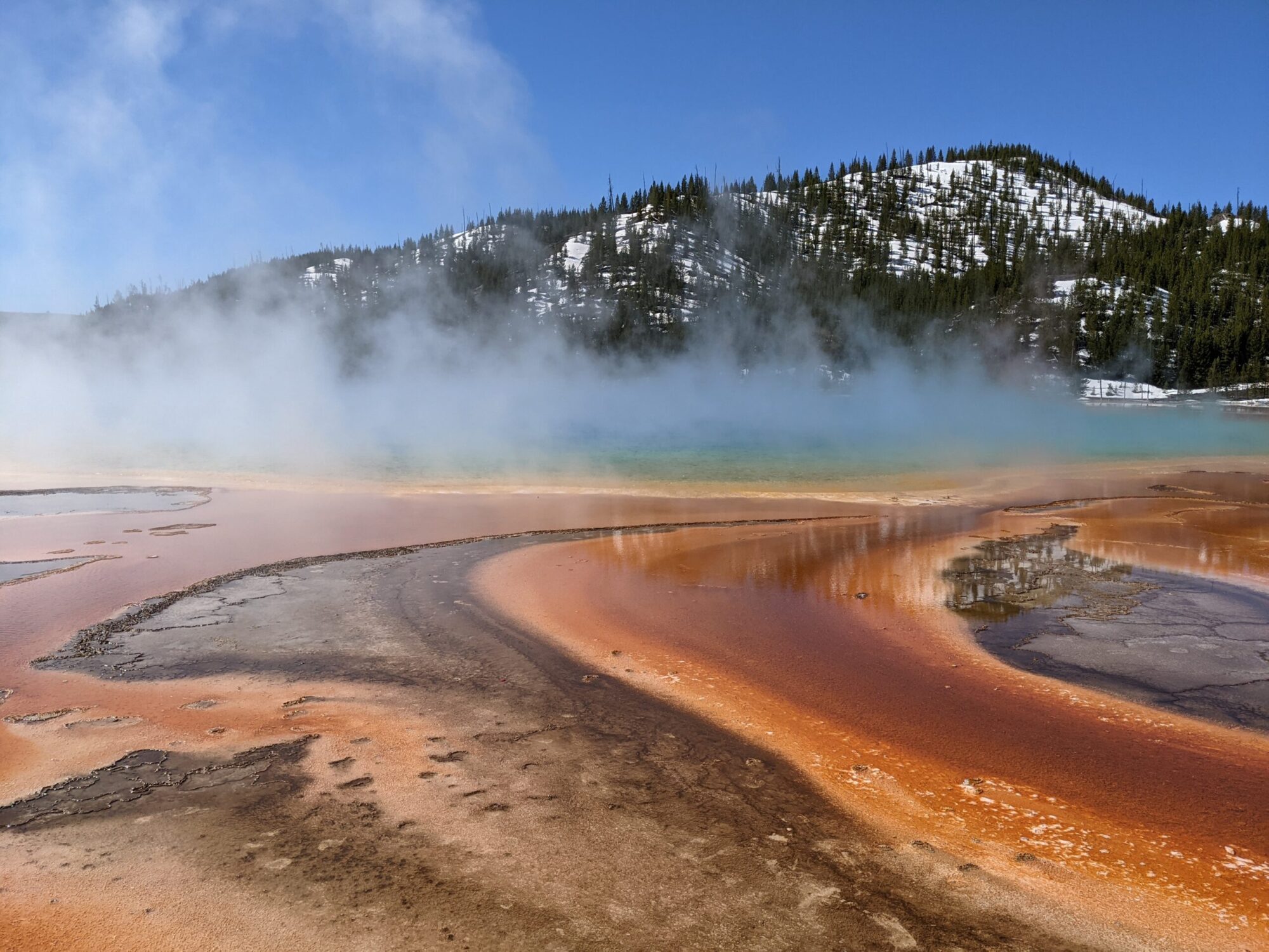
That….all….being…..said…. We first stopped at Edge of the Cedars State Park, which happened to be in Blanding! They’ve got world-class research facilities and artifacts, including the room pictured above. They’ve got pottery dating back over a thousand years, and with the computer in the bottom-left, you can select an artifact and learn more about where it was discovered and what was painted on the pots, if anything. It was a pretty neat display!
Out behind the museum, they also have a ruin that can be entered. We saw many such ruins, called kivas, as we visited various sites in the region. These were the “village centers” of small communities, where the structure would be dug into the ground, then bricks stacked in a circle around, and then finally a roof thatched with timbers and clay that was strong enough to walk on. In the center of the structure, a fire could be set up, and a ladder would descend from a hole in the top that allowed smoke to come out from the fire. They Ancestral Puebloans believed that passing through the smoke was a spiritual experience.
There was also more modern art along a short trail behind the museum, including this piece that acted as a sundial. You can see the shapes cut into the piece, including antelope and dancers, and the sun would then pass through those shapes, projecting to the inside. On the summer and winter solstices, those images combine to form a line on the inside, which is probably pretty cool, though we aren’t planning on driving back in late June to find out!
After we were done at Edge of the Cedars, we headed toward “House on Fire,” which is in Mule Canyon, but on Bureau of Land Management (BLM) land. Before we went in, we visited another ancient kiva that was preserved until a permanent shelter. Here, you can get a better sense of what a lot of these look like. Typically, they are in a circular shape like this one, however the bottom of this one has more sand in it, rather than a fire pit. You can see what looks like a tombstone on the right-hand side of the floor, and that was a “reflector,” of sorts, so the fire in the center of the kiva wouldn’t be blown out by the air vent coming in from the right side (the hole in the bottom on the direct other side of the “tombstone;” that hole went to another hole further from the kiva, coming out of the ground).
We then took the trail toward House on Fire. As this is BLM land, trails aren’t as well marked as we’d like, so we weren’t entirely sure we were going the right way for awhile! No one else was with us, though we’d eventually run into some others as we got closer to the site. The trail was up in the grass, but also down in this “wash” picture above. We moved back and forth between the two routes. I was wearing my Chacos, so I wasn’t as well-prepared as others (I didn’t know we were going to be in a sandy ditch….sue me….), but it worked out alright. The hike was less than a mile out before we reached our destination.
“House on Fire” gets its name because, well, there’s a house built under the rock face, but also because depending on the time of day and how the sun is hitting, the erosion in the rock face looks like it’s…..”on fire.” We unfortunately didn’t get to see anything so spectacular, but it was still pretty cool! There was another couple there who had been there since 9:30 and they hadn’t seen anything, either. We were told 10:00-11:00 was probably the best time of day to be there, and we arrived closer to 11:30, but again, apparently we didn’t miss much. For our first “up close” cliff dwelling, it was pretty neat!
The walk back, again, featured the same trip we’d already taken, but I wanted to point out the varied terrain. Unlike what we see in Missouri, where a trail is a trail is a trail, in Utah, you can be in a sandy “wash” like we had above, or through a more grassy soil, or on flat rock like above. We’d hit other trails later on in the vacation more like this, but I think it was interesting for the kids to experience such a difference!
Calvin, at least, found it interesting. Meg mostly grumbled.
Our last stop of the day was Natural Bridges National Monument. Arches National Park is near Moab, UT, which makes it a very popular tourist destination. We’d already decided that we didn’t want to deal with that, so instead, we figured that the kids need to see some arches, but maybe bridges would be close enough!
The difference is that an “arch” is formed by any number of things, like erosion from seeping moisture, whereas a “bridge” is formed by erosive action of moving water. For example, water hitting a rock face and being diverted around it: over time, that water would eventually punch through the rock, creating a direct route underneath, whereas the original, diverted water would now exclusively flow in the new channel, leaving the old one dry.
There are three main bridges in the area, all of which can be seen and hiked to. Sipapu Bridge and Kachina Bridge involve relatively strenuous hikes down, so the kids weren’t all that enthusiastic about trying that (they also weren’t crazy about an 8.6 mi hike to see all three of them…).
Luckily, Owachomo Bridge was pretty easy to get to, and it’s the largest one, so that’s what we did! I mostly wanted to include this picture because it’s a good one, but….
This shot provides better scale to see just how big it is. Meg is standing in the middle of it, at the bottom. Pretty cool!
After we left Natural Bridges National Monument, the real adventure began. Brooke wanted to try an “off road” trip that wasn’t necessarily difficult, but still took up off the beaten path a bit. Leaving Natural Bridges, we noticed a dirt road that went around Bears Ears National Monument, which is one of the newest in the system. The sign said “15 miles,” though we admittedly can’t remember specifically to where it was indicating, and given where we ended up going, it may have simply meant “to the end of the road you’re getting on right now.”
This trip took us nearly 2 hours to do what we thought was 15 miles. Brooke was driving (thankfully), and we were going pretty slowly. Some stretches were fine, with some slow ups and downs, but others took us at a 4 degree angle up a one-lane cliff where I didn’t want to look over Brooke’s shoulder to the canyon below. We kept watching the mountain on our right wondering where the pass was going to cut through, and it continued to not do so.
I’m still working on my best estimate as to how far we actually went, but 45 miles is what I’ve got as of writing this (I may edit it as I plug through Google Maps to figure out which road(s) we were actually on). I know we were on Burch Canyon Road for most of the scary stuff, and then we got off onto Wooden Shoe Road for awhile before passing right by Bears Ears East. The GPS tag on the pictures I took confirm we made it at least that far. We also know we ended up on CO-95 when we finally hit pavement again, but specifically where is what I’m a bit fuzzy on. Still, it took quite a bit longer than planned and, after all that, it was time to head home so we could decompress a bit.
It’s good to have an adventure like that sometimes! Next time, maybe we’ll do it at a lower elevation!
The next day brought new challenges, though, when we hit Canyonlands National Park!
We made it to Redstone, CO around 4:30 pm MDT on May 30th: just enough time to explore a bit before dinner. We ended up staying at Redstone Cliffs Lodge on the recommendation of my buddy and colleague, Waylon, who was in the area for his annual elk research project. Our hope was that, being the height of elf calving season, we’d be able to meet up with his research group to watch “the miracle of nature” take place and see an elk calf! Unfortunately, it didn’t work out that day, so we ended up finding other things to do.
Still, Redstone Cliffs Lodge was situated in a really neat area, one that didn’t involve all that many tourists and one that showed off a side of Colorado we don’t always get to see, especially if you stay in Denver, Colorado Springs, Fort Collins, etc.
The Lodge itself is fully featured, including a kitchen, a fold-out couch, two queen beds, heating (no need for A/C, and the Crystal River is running just behind it, so you can light a fire by the river or sit in the hot tub. It’s also two doors down from Propaganda Pie, which was awesome. Pizza is their “claim to fame,” but they’ve got pastas, salads, a solid beer selection, etc. We were there for dinner both Thursday and Friday nights, and on both nights, there were parties going on. It seems like Propaganda Pie is the only game in town for gatherings like that (literally), but also in the general region, so folks from neighboring communities also come in.
I should note that there isn’t a grocery store in Redstone, so while cooking was an option (and we did take advantage of the kitchen for leftovers!), you have to go north to Carbondale, CO if you want more amenities. As long as you come prepared, it’s a peaceful time and worth the stop! Redstone also has an ice cream shop/general store that the kids visited, and looks like it has some antique-type places (that we didn’t visit).
Since the whole “elk calving” thing didn’t work out, we found other things to do! Nearby, close to Marble, CO, we visited Beaver Lake, hoping to make it to a waterfall. We couldn’t find a way to get there without crossing private property, so we just walked around and enjoyed the beautiful day.
Actually, Marble is an interesting site in its own right. As its name implies, there’s a marble quarry there that is still active to this day. Coincidentally, marble from that quarry was used in the construction of the Lincoln Memorial and the Tomb of the Unknown Soldier. Neat!
From there, we tried going on an adventure to Crested Butte, CO, but tried to get there via CO-12 by crossing Kebler Pass. It’s closed in the winter and, apparently, May 31st still counts as winter, so we couldn’t go that way. We had our lunches with us, though, so we continued on that road to Erickson Spring Campgrounds, which is managed by the National Park Service. After eating our sandwiches by a creek, we hiked down Dark Canyon Trail for just under a mile, before things started getting really muddy and difficult. It was an easy little hike and a beautiful day to be outside!
That evening, we hit up Propaganda Pie once more, and Waylon joined us for one more outing before we were to take off the next morning. He usually stays in that region of Colorado through June, and is then off all over the place for July and most of August, so we probably won’t see him again until school starts. Regardless, thanks for the recommendations, man!
The next morning, we were heading toward our ultimate destination for the trip: Blanding, UT. If we went north to I-70 and took the “normal” (boring) way, it’s a 5 hour trip, so instead, we went south through a more interesting route that would take more like 5 hours…..and 9 minutes. So yeah, it was a pretty easy decision!
The trip was mostly uneventful. We stopped in Montrose, CO to pick up some groceries prior to heading into Utah as, again, our options were probably going to be limited for the next few days. There’s a grocery store in Blanding, but’s somewhat limited in options.
(Spoilers: The grocery store there is pretty good, honestly. Some things are the same price that you’d find at the Aldi in Marshall, whereas things like avocados, bananas, and cheese were pretty pricey. In general, things that spoil are a bit more expensive!)
We arrived at the house around 4:20 pm MDT on June 1st, which was a Saturday. This is good in that it gave us a chance to check out the grocery store in town to make sure we were good to go. Also, so that we would know that the grocery store is closed on Sundays (because Utah), so we grabbed a few extra things just in case!
We booked the house through Airbnb months ago and the hosts were pretty flexible with us, even shifting the dates around after we decided to add in the Redstone leg. There are 3 bedrooms, one full bathroom, and the kitchen/dining/living room section is all pretty “open concept.”
Whereas our internet speeds in Redstone left…..much….to be desired, the signal there is pretty solid. It still isn’t anywhere near speeds we normally get at home, but at least streaming content is doable. This was going to be a struggle with the kids, and thankfully, it wasn’t…
The house was our home-away-from home for 6 nights, from June 1 to June 6. Brooke found this location because it was centrally located to a bunch of sites in southeastern Utah, but far enough away from more tourist-y places like Moab, UT to keep the cost to below $1000, which we thought was pretty reasonable. For a home base, not bad!
There were a few “quirks” to the house, though. The kids’ bedrooms were pretty close to one another, and their doors didn’t close very well…or at all… The electrical in Meg’s room was limited, with some lights not working…at all… The kitchen area was pretty nice, though there weren’t hand towels, there was a weird assortment of glassware, no mixing bowls…just kind of odd. Most of the necessities were there, though, and part of the fun of Airbnb is not necessarily being sure what you’re going to get when you arrive!
Brooke’s got it on her list to make sure she brings more aluminum foil next time we stay in a place for that long, though.
It’s that time of year again! Thankfully, this time we left a little earlier this year so I’d be less stressed out with the next school year looming. Like last year, however, we left in the early afternoon so that Brooke could put in a few hours of work and the rest of us could get the car loaded. We left a little later than Brooke wanted to, on account of me not being quite ready yet, but we were out the door around 12:30ish.
Of course, we made it past the Marshall Junction and I asked whether the new tablet holder (mounted on the passenger seat head rest above) worked, so Calvin was going to try it out…..only to find that he’d left his tablet on the counter at home…
Thus, we turned around, grabbed it, and left closer to a little after 1:00…..
The goal was to make it as far as we could, and if we were lucky, we’d hit Hays, KS. Luckily, we didn’t really hit any traffic in Kansas City, nor construction anywhere else. And Kansas is Kansas, so there isn’t much to see… We ended up pushing it all the way to Limon, CO, which would only leave us around 4.5 hours to reach our destination for the next few days!
We rolled into Limon after 9:00 pm MDT (which is 10:00 CDT….so the rest of the family was rather tired…), so we slept in a bit the next morning. After we grabbed breakfast, we headed toward Denver, looking for something to pass the time before hitting our destination for the night in Redstone, CO, which is on the other side of the Rocky Mountains.
My buddy, Waylon, works out in Colorado in the early summers, and given that Utah, doesn’t have the best beer selection, he recommended getting some on the other side of Denver. Near there, we found the Colorado Railroad Museum, which ended up being a pleasant surprise!
They have quite a few functional engines, as well as some that are being refurbished. The tours are run mostly by volunteers, all of whom seemed to really enjoy what they were doing. The gentleman pictured above was enthusiastic talking to the kids (and the adults……) about the differences between North American Morse Code and International Morse Code (there’s a difference?!), the history of those differences, and how the codes are mostly obsolete, but still used to this day by intelligence forces as they listen in on communications overseas.
There were quite a few things to see, some of which included relatively modern dining cars, or older refrigeration cars, or postal service cars. The engine pictured above featured a series of levers that had been attached to a sound simulation system (that used to cost $0.25, but the lady said they don’t charge anymore because no one carries change!). She gave direction on how to increase and decrease speed, ring the bell, and so forth. It was pretty neat!
They also have a “roundhouse” that puts engines under a roof for repair, and can then bring them out as needed (you know, like in Thomas the Tank Engine). They don’t actively pull trains out of it, but it was set up so that the kids could push the turntable around with a big, wooden lever. Calvin struggled a bit, but with a little help from the volunteer, they got the job done!
The park is geared toward children, but there were cool activities for the adults. There was a train ride that takes a trip around the grounds 3 times where passengers can ride in a late-1800s passenger car. They also had a series of miniatures, one of which was outside (with an example of the aforementioned Thomas the Tank Engine, naturally…). The model was cool, and featured some of the same buildings that were around the museum.
Down in the basement, they had a classic HO scale train set that was pretty intricate. There wasn’t a lot of interaction from the outside, but there was a ladder that could be slid along so kids could get a better view. It was pretty impressive, and reminded me of yet another hobby from my childhood (and before) that’s slowly disappearing.
After that adventure, it was time to cross the Rockies! Rather than taking the Eisenhower Tunnel on I-70, which we have taken quite a few times over the years, we decided to go the scenic route and take Loveland Pass. It wasn’t a particularly difficult journey or anything, though the two-lane roads following large trucks can be annoying. Really, it was the “uphill” that took longer, and after we’d stopped at the pass for a few pictures and starting heading down, we made good time.
As always, it’s fun to see so much snow when it’s late-May and you’re from Missouri! It may not look like it in this picture, but it was pretty chilly up there, which made us question the shorts-and-t-shirt wardrobe we’d chosen. We weren’t out there for very long, though!
We looked for a few abandoned gold mines to tour, as that’s the kind of activity both Brooke and I enjoyed from our childhoods, but the railroad museum had to suffice: the gold mine tours we found looked pretty “tourist-y” and not all that cheap for what would be an hour or two of time to kill. Next time, perhaps!
The final leg of our Southeast-ish tour took us to Nashville, TN. The plan was to go to the Grand Ole Opry, but that was scheduled for Saturday night, when their regular radio broadcast is produced live a laPrairie Home Companion (RIP).
But first, we headed into Nashville, and oh boy, was it raining cats and dogs for most of that trip. In fact, most of the times I found myself driving, we went through a downpour of rain (that rarely actually hit Missouri, apparently…). So while we had grand plans to visit the Gilded Athena, among other sights, we ended up delayed due to weather and didn’t end up doing all that much.
It also took us…forever….to even get to our hotel, the Grand Hyatt Downtown. We were running multiple GPS systems in trying to figure this out, but long story short, Nashville decided to tear out a bridge that was directly in front of the hotel, and the hotel didn’t really warn us about how to handle this, so we ended up circling around quite a bit before we figured out where to unload, where to park, how to physically enter the hotel, and so on. It was a truly frustrating experience, compounded by the rain (not pictured above).
Ultimately, we figured out where we were going (it was a really nice hotel room, though, I’ll say that much…) and decided to venture downtown to see what was going on. We went to a restaurant that was pretty satisfying after so much frustration (note: Nashville is not in a dry county like Pigeon Forge is. Win.).
After that, we walked around and….um….there was a lot going on in Downtown Nashville that day. Seriously, it reminded us more of Bourbon Street in New Orleans with all the activity. I don’t know if the students were back in town partying at 2:00 pm on a Saturday, but there was a lot of “that” going on. It was a far cry from our experience the rest of the trip.
One thing Brooke looked up, that I was completely unaware of, was Goo Goo Clusters. Their store was set up such that you could buy the traditional Clusters (peanuts, caramel, nougat, chocolate), or you could design your own, or you could get different flavored bonbons (pictured above). It was a pretty neat, yet simple, experience, so both kids chose what they wanted in their personalized Cluster, then they could watch it being made in front of them. We also picked up a box of the original recipe version, as well as a bonbon mix. It was a good distraction!
We then hustled back to the hotel to clean up before the Opry performance. There were a lot of people there, but a neat thing is that they had a secondary stage outside (with some food trucks) with live music going on before the real thing began.
I didn’t have much of a connection to what, exactly, was going on with this, but Brooke was more aware of what Grand Ole Opry is. They’ve produced a radio show for years, and it’s now broadcast on Willy Nelson’s SiriusXM station live on Saturday nights. It’s mostly a traditional country music showcase featuring some regular musicians, as well as special guests that perform a 3 song set. It’s pretty steeped in tradition, as the original location was in an old church, the Ryman Auditorium, also in Nashville. The current Grand Ole Opry is a larger recreation of the Ryman, complete with church pews as the seating.
The concert was good! The music isn’t exactly my preference, but the kids haven’t been to all that many live performances like this, so it was a good experience for them. The girls having fun with their presumed bachelorette party behind us were also having a good time….much to our detriment…
The next morning, we took off for Marshall and made it home in good time! Overall, it was a good trip: perhaps not as memorable as what we did on the West Coast in 2022, but still, a nice time. We have decided to never take a vacation that close to school starting again, though, as that created more problems than we anticipated, and probably added to the stress we were trying to alleviate. Still, we’re glad we made the trip and knocked a few more National Parks off the list.
Spoiler Alert: we already have reservations for a house near Moab, UT next June. Onward, 2024!
The day we left West Virginia, we spent a lot of time on the road, but ultimately made it to Pigeon Forge in time for dinner. Our hotel happened to be next to a mini-golf course that had two 18-hole courses available, so after we ate, we checked out mini-golf (always a popular activity!).
We drove in on a Wednesday, leaving us with Thursday or Friday to hit Dollywood and Great Smoky Mountain National Park. Weather was supposed to be a little more on the rainy side, so we opted to hit Dollywood on Thursday and save Smoky Mountain for Friday.
On the one hand, this ended up being a great decision! We didn’t realize it, but school was back in session for much of Tennessee and West Virginia. That, combined with some spotty showers that morning, meant that practically no one was at Dollywood. As I said at the time, had we paid for the “Lightning Lane” equivalent, I would have been asking for our money back, because we were able to walk up to any ride we wanted and, sometimes, be the only four people riding it.
We hit every roller coaster we could at least twice, if not more. Even some of the smaller ride, we hit multiple times. Mind you, I don’t have pictures of many of these rides because Dollywood had a locker system set up and wanted people to leave their phones, purses, etc. in those lockers. We ended up paying for a day pass that was actually pretty slick, as you could have a temporary “log in” system to the lockers at multiple locations. Once you registered at the new location, the previous one would “log out,” opening that locker up for someone else to use. Since it was raining, we had hats, rain jackets, etc. with us, so I usually just tossed my phone in there, leaving few options for pictures.
The rides were good, but in comparison to Disneyland, a bunch of these roller coasters were giving me a serious headache. Brooke and I felt more “jostled” by the rides at Dollywood, where some were smoother than others, but a few of them tossed my head back and forth to the point that it was uncomfortable. At Disney, at least there was a 30-40 minute lag between rides, but since no one was at Dollywood, it was closer to hopping off one ride and getting right back on it again with little break in between.
There were Silver Dollar City vibes in various places, such as candle making, metal working, etc. They even had a “Fire in the Hole” knock-off called Blazing Fury that was practically the identical ride, complete with someone saying “fire in the hole!” toward the end.
We avoided treats for the most of the day and saved it for an all-you-can-eat family-style meal at Aunt Granny’s Restaurant, which is considered to be one of the best theme park restaurants around. I can’t say the meal was cheap, but as Calvin’s face above suggests, there certainly was a lot of food. It was all very good, but we didn’t put away much of it.
We only ended up spending one day at Dollywood, and given our experience at Disney last year, one day sure didn’t sound like enough….however, since there was no one there, I think we were all satisfied with a day’s worth of a visit.
The next day was a Friday, so we hit up Smoky Mountain National Park. This day, unfortunately, was rather disappointing. There were simply too many people, meaning we were stuck in long lines of cars with few opportunities to pull over and do much. I had to hop out of the car to get a parking pass (that’s how they limit entry there, as opposed to how they do it at Yellowstone where there is a pass you have to purchase to get into the park in the first place.
It also ended up being somewhat rainy, which isn’t too surprising given the climate of the area. We had rain jackets with us, so it wasn’t a huge deal, but it limited how much outdoor time we actually wanted to spend in the park. We hiked a bit to see some old buildings that were still standing from before the National Park was there, and we saw some exhibits like a grain mill that was still semi-functional, but honestly, we kinda stuck to the car.
I think by the time we were hitting Friday, we were kinda done with seeing the sights. Brooke and I still like the park, but I don’t know that the kids really got much out of that day. There were simply too many cars (and people in them….) to feel like we could get out and do much. It’s saying something that the lines at Smoky Mountain were worse than the lines at Dollywood, but again, perhaps because we did it on a Friday, we invited the situation onto ourselves.
For our last evening in Pigeon Forge, we ended up struggling to find a place to eat within walking distance of the hotel. There were a lot more people out and lines were long everywhere, but we eventually found a place. We hit the second 18-hole mini-golf course next door to our hotel to end the day, though, so I think that made up for an otherwise disappointing day!
One of the plans for this vacation was for everyone to learn to play poker. The house we rented had a poker table, where the top of it flips over to expose cup holders and a felt table top. I picked up a few rolls of coins so we’d have something to use, and Brooke printed and laminated a few “cheat sheets” with which hands beat what. We didn’t end up playing a ton, but we got a few hours of entertainment out of it. Meg ultimately won, though she didn’t really bet all that often, so that’s my excuse…
Since we explored a bit on Sunday, we reserved Monday to mostly just hang around the property. There was an old logging road that went for a few miles up onto the mountain that Brooke and I checked out, but the heat, humidity, bugs, and elevation change made it rather unappealing to go hiking. If we were there in the Spring or Fall, though, I think we’d be able to kill a ton of time just walking around and exploring the area. It really was a beautiful place!
We used the hot tub a few times, mostly in the evenings. The owners rigged up a neat pulley system to lift the lid on the hot tub (that had previously been used to butcher deer, we think). This way, Calvin could get the lid off by himself without our assistance. They also had fencing around the top of the tub so that no one could fall off the porch if they were sitting on the side of the tub.
We did take a hammock along, though Brooke only used it once. Again, we had intended to mostly just hang around the property for at least one day, just getting some relaxation in. We had Wifi at the house that worked surprisingly well (no regular cell service, though), but you had to be pretty close to the house for it to work. It was nice to just hang out for a day without having to travel anywhere!
For our last day in West Virginia, we visited Shenandoah National Park. This park was…..weird…compared to what we’re used to seeing. For one, it’s really a series of plots of “park” along a two-lane road, where you can pull over sometimes, but mostly, you’re just driving through a forested area. There were some overlooks, but nowhere near as picturesque as Colorado or Utah. As in, the overlooks we’re used to seeing to pull over, get out and take pictures….there existed, but there weren’t a ton of them, and they were overlooking a land mass that didn’t look that different than the Ozark Mountains, so it was a bit less impressive than we were expecting.
Also, a huge storm blew through the previous day. We were at the house when it happened, so it was cool to watch it come through, but apparently a lot of other communities lost power when our house didn’t (incidentally, the owners lost power and checked in on us to make sure ours still worked…and it did!). Well, the Visitor Center we went to in Shenandoah was still without power, though they had a generator to keep a few things working. However, they a). couldn’t process credit cards, and b). their exhibit was shut down, so we could really only go in to ask a few questions, but not really learn much about anything there.
We had found a 4 mile loop trail that was supposed to pass by a waterfall that was relatively close to the Visitor Center, so we found it and got started on the one longer hike we did on the whole vacation. It was, indeed, a loop, and there were a decent number of people out there on it. I wouldn’t say it felt crowded, thankfully, and we were able to get a parking spot relatively easily. The loop wasn’t too bad, nor was the terrain, though the temperature did start to rise a bit. The kids were a bit tired (as evidenced by the image above), but Brooke and I were fine.
I would have liked to do more hiking if we had more time, but it ended up taking an hour and a half to get from the house we were staying at to Shenandoah, and the actual drive through Shenandoah added another hour…which means we were now an hour north of where we started, and we had to drive that full distance south to actually get back home. Anyway, it ended up being a longer driving day than I think we were initially thinking, but we’re still glad we did it so we can check it off the proverbial list.
While we were there, we also made sure the kids got to walk along the Appalachian Trail….for all of 100 feet. At least they can say they’ve been on the AT before!
After all that, we were ready to chill in the A/C for a bit! We still played more poker that night and got in the hot tub, as it was our last night in West Virginia. The kids were happy to just lay down and rest a bit, though, and the house provided plenty of space to spread out. It ended up being a good place to stay, getting us rested up before the next few days in Tennessee!
Since last year took us all the way to the West coast for our family vacation, this time, we opted to head in the other direction. The original plan would have had us make it all the way to the East coast to hit North Carolina, but Brooke and I already went to San Juan earlier in the year and we had the foundation of our house re-done, so we scaled back plans just a tad.
Calvin was in Columbia with my parents for the week at an art camp, so we loaded things up on a Friday and took off to pick him up before heading out. We had decided to stay in Evansville, IN for the night because that got us closer to our destination, but would also set us up to see Mammoth Cave that next morning. The drive to Evansville was mostly uneventful, and we found Turoni’s Pizza and Brewing for dinner, so at least I was happy. While we were there, a magician was going from table to table doing some tricks, so we got a kick out of the dinnertime entertainment!
The next morning, we had an appointment at Mammoth Cave, but only had about 2 hrs of driving to get from Evansville to get to the national park. There were multiple tour options available, but we stuck with a cave tour that would last long enough but not too long because we were still making the rest of the journey that afternoon. There were some cool lantern-light tours we could have done, but those take around 4 hours and we didn’t have that kind of time!
The facilities at Mammoth Cave were pretty good, with a big gift shop and ticket area. There was also a set of exhibits talking about geology and the various organisms one could find in the cave. Apparently, Mammoth Cave is the longest known cave system in the world, clocking in at 426 miles (and that number keeps changing as more areas are discovered).
There were definitely impressive aspects about Mammoth Cave, among them the size of the open spaces. Of course, there were definitely areas that got pretty narrow, and I absolutely bumped my head a few times during the tour. We were a part of a relatively large tour group, so it felt kind of slow getting through aspects of it, but I don’t think we got the sense that there were a lot of stairs, or climbing over boulders, or anything like that. The tour lasted for an hour and a half, but I don’t think we left it feeling tired or anything. It was very hot and humid outside, though, so we were glad we were at least wearing jackets, because there were plenty of other folks in there that looked pretty cold!
If I’m going to make comparisons (which I do…), I would say that Mammoth Cave was unimpressive in the “rock formation” department. There were things to see, but really, it just felt like we were walking through big, open spaces under the ground. This picture above represents perhaps the only traditional rock formation that I’d expect to see in a cave in Missouri. I know that’s just representative of the geological differences between caves in Kentucky vs Missouri, but still, I was surprised that there weren’t more things to see like we saw at Meramec Caverns in 2020.
After we were done at Mammoth Cave, we booked it to our destination for the next few days in West Virginia, but we didn’t get there until well after the kids’ (or Brooke’s) bedtime. We were in Eastern Time by this point, but it was pretty close to midnight by the time we got there and got settled.
The next morning, we were able to survey our surroundings a bit better! Brooke found a few houses between Airbnb and Vrbo that were (on a map…) centrally located to various outdoorsy things in the Appalachian Mountains, and she let the kids determine which of the houses we would stay in.
Of course, when we let the kids make that kind of decision, they tend to make really weird choices, so I was a bit apprehensive about this decision, but once we got there, it was actually fine! The house was down a gravel road that went past a few other properties, and this house was at the end of that line. It had 6 bedrooms and, as you can see above, it had been added onto at least a few times over the years. The kids liked it because of the number of bedrooms, and it also came with a hot tub (pictured on the front porch above).
Still, the house was pretty far from most things. There was a grocery store “in town” a good 30 minutes away, but going anywhere from this house definitely had to take time, no matter what we did.
We couldn’t argue with the view, though! It was beautiful there! There was a small creek running past, as well as a few outbuildings that were dilapidated to the point that the owners said “uh, don’t go in there…”
Later that morning, we went to check out the “highest point in West Virginia,” that just so happened to be located relatively close to the house. It was something to get us out to see what the surrounding area looks like in the daytime, but that wouldn’t overwhelm us on the first day out there. Also, this particular “hike” was less than a mile long, so it wasn’t a huge ask of the kids.
There was an observation tower at the top of the “highest point in West Virginia,” so we climbed up there, but the tree line was actually relatively close to the top of the tower, so while we got a decent view, it wasn’t completely unobstructed. After that, we walked around a bit more on the trail that was up there, but there really wasn’t much else up there to see.
After that, we went to the closest town, Franklin, WV, to get lunch at one of the few restaurants in town, AGK Italian Restaurant & Pizzaria, which was right next to T&K Market so we could load up on groceries for the next few days. For the rest of Sunday, we mostly hung out around the house!