This post is part of an ongoing series summarizing each State Park in Missouri that our family has attended. We hope to visit each of 54 State Parks before the kids graduate from high school.
Back in May of 2016, we went camping at Pershing State Park. It was named for Gen. John J. Pershing, who grew up in the area and explored it as a kid. It’s located in the north-central part of the State, so Brooke and I had visited the park back when we were in college, so we thought it’d be cool to check it out with our kids.
The campsite we stayed at was just a short walk to a small pond. Calvin and Meg weren’t particularly great at fishing, but they still had fun! If I remember right, the kids got their lines stuck in branches a few times and didn’t catch anything, but oh well – it killed some time.
The campsites were pretty flat and covered in trees. It was easy enough for them to entertain themselves around the campground. We were there in mid-May, so the temperature was pretty reasonable: chilly at night, nice during the day, not many mosquitoes yet. There was plenty of wood around to make a fire with, and that’s always entertaining to 2- and 5-year-old kids.
We didn’t do a ton of hiking, but Pershing has a pretty cool walking trail through some tall grasses. There wasn’t much wildlife aside from birds we could see, but the kids enjoyed hiding from each other, darting around corners behind brush. The boardwalk pictured above is a short loop within walking distance from the campsite. We did our best not to carry Calvin all that much, but we didn’t have much of a choice unless we wanted to sleep on the trail forever…
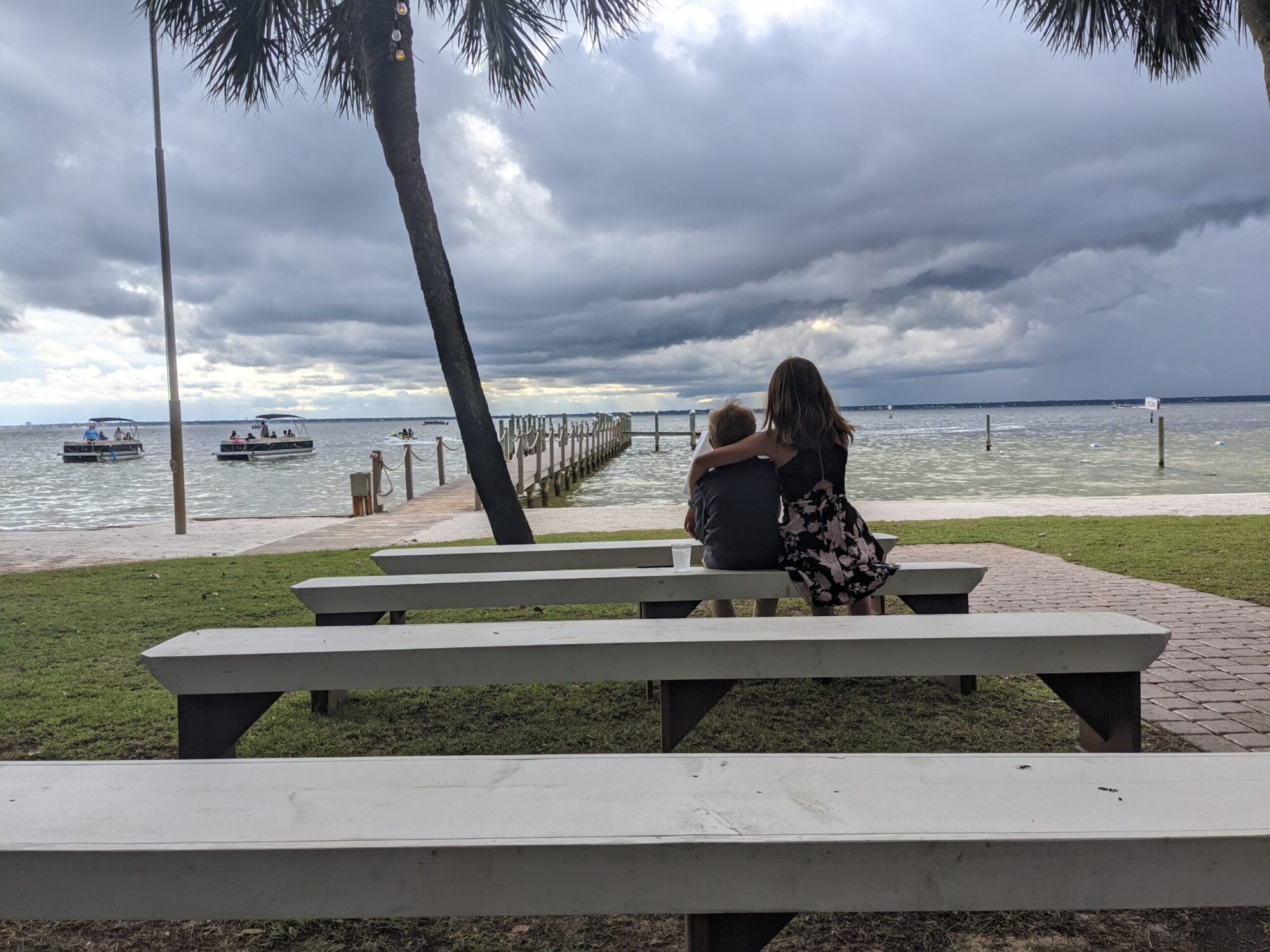
There was also a cool observation deck where you could watch for water fowl in the marsh. The kids took their sweet time climbing up to the top, despite the fact it wasn’t even really that tall. Remember, Calvin is among the slowest people on the planet and it was even worse when he was 2…
Overall, we had a great time! It was also a relatively short drive for us, which is always appreciated. I don’t remember there being a playground all that close to our campsite, which would have been nice, but our kids were of the age where they could “make their own fun” so it wasn’t a big deal.
We’d go back! It’s definitely worth the return trip someday!
This post is part of an ongoing series summarizing each State Park in Missouri that our family has attended. We hope to visit each of 54 State Parks before the kids graduate from high school.
So, I last posted about State Parks last May. For real, this time, I’m going to get a few more in the virtual can. It’s on my “Christmas Break list” and Brooke keeps reminding me to work on them.
We last visited Rock Bridge Memorial State Park near Columbia in April 2017, though Meg first visited back in 2012, before Calvin was born. As close as we live, and as often as we’re in Columbia, you’d think we’d go more often, but alas.
The proverbial “rock bridge.”
The park gets its name from an unusual rock formation carved out by a creek over many years. Growing up, we used to be able to actually walk through the bridge, but a few years ago, they removed the wooden walkway. To be fair, they’d have to close the walkway any time the creek flooded, so perhaps it’s for the best.
Meg was a bit smaller back then…
Brooke and I both went to the park growing up, actually. Mom and Dad took my sister and I and we both went on school trips relatively frequently. I never got to go down in the “Devil’s Icebox” cave, but Brooke got to back in high school. I also participated in an orienteering activity there in 8th grade, which Mom fondly remembers.
Some relatively light hiking around the park
The hiking around the park can be as strenuous or as simple as you want, with many trails set up on wooden slats, and other portions being traditional dirt trails. The park is pretty big and has campsites, but I don’t remember ever camping there. My experience is mostly just the hiking around the park, but even with that, I never really went all that far.
That kid…
The aforementioned Devil’s Icebox cave is somewhat popular among amateur spelunkers. Honestly, I’m not sure I’d even gone down as far as these pictures here indicate. The kids found it pretty awesome to be down in a cave by the rushing water. We didn’t get all that wet, but they did go out in the middle of the water out on some slippery rocks.
We’re in a cave!
We may end up camping there at some point, but for the time being, we’ll probably just visit when we get some time in Columbia. It’s a fun and easy park to walk around in so we’ll definitely head back…but we have quite a few other parks to hit, too!
After last year, I wasn’t sure Meg would want to try backpacking again for awhile, but late last summer, it came up again and she seemed interested. Since then, every once and awhile, she framed it as “when we go back to Bell Mountain next year,” so it appeared that she had forgotten the serious amount of crying she did a year ago…
We had a limited window to pull this off, as I’m doing summer classes again starting in early June, and importantly, Calvin will be home for most of the summer, making it difficult to make a trip like this. Combine this with the fact that the high temp is in the low-90s for the next week, we opted to do a one-night trip down on a Tuesday when the high was 83 F and the low was 60 F.
Just the two of us.
It rained the day before, so by the time we got down there (four hour drive…), it was pretty moist along the trail.
Taking a step back, I should also note that we learned a fair bit about the trail and opted to start from a different location. Last year when we did this, we parked at the southwestern end of the loop and had to hike uphill along a rocky creek bed…and infamously, we missed the turn and went the wrong way. This time, we parked at the northeastern lot and had a much easier time. The trail in was mostly flat, though, again, somewhat muddy from the rain the day before.
We took a left first to head up to the Bell Mountain peak to get some pictures, then turned around and headed down to the creek we never found last year. When we got there, we found plenty of water to make our evening run far more smoothly than last year! We did about 5.4 mi that first day.
Meg liked drawing in her notebook
It was pretty easy to entertain Meg at this site. She waded across the creek with her sandals on a few times, threw some rocks, drew some sketches in her notebook, and filtered some water for me. That latter part was of particular interest, so she made us keep hydrated so she could filter more water.
The site was perfect, of course. The creek was next to a permanent fire pit and in a semi-open area that was flat and cleared for tents. Again, this is where we wanted to go last year, but never made it. I’m pretty sure Meg would have enjoyed last year quite a bit more had we actually found it…
She also liked filtering water!
We had macaroni and cheese (again) that night and, having the water source nearby, it was easy to do dishes with plenty of water, making the cooking experience more efficient than last year. I couldn’t get a fire going because the wood was so wet, so we ended up playing card games in the tents. Crazy Eights, Go Fish and Memory were the choices, and I’m pretty sure Meg won them all. It was pretty hot still, as it didn’t cool off into the 60s until after midnight. We stayed up until 9:00ish and fell asleep quickly after that.
Turns out Meg is good at Crazy Eights…
The next day, we packed up quickly and made it back to the car around 10:00. It was about 3.5 mi or so and Meg didn’t start flagging until toward the end of it. The drive back was mostly uneventful and we made it back to Marshall by mid-afternoon, plenty of time to air things out and grab showers.
It was a great trip! Two nights may have been better, but one night was plenty. Perhaps next year we’ll try somewhere else!
Brooke wanted to get a test run in on the tent and camping gear before we head to the Grand Canyon later this summer. The logistics of this trip were somewhat…”rushed”…as it was the weekend before Finals and we’d been busy for the weekends running up to it.
Meg and I went before Brooke was off work so we could get the tent set up. The site itself was very flat (as all the sites at Van Meter are), though we had to move some leaves and sticks around. It was pretty early in the season still on April 27th, so few people had camped in the area in 2018 before we got there.
Yay, dinner!
The weather was set to be great and it largely was. It was pretty breezy Friday evening, but we were still able to get the fire going and roast some hot dogs. We didn’t stay up all that late, as the temperatures were falling and the wind was blowing around the smoke all annoying-like…
…and…breakfast…
The temperatures dropped to ~42 F overnight and, while the kids slept just fine, Brooke and I were not as fortunate. I was mostly warm, but Brooke got a bit chilly (and she subsequently bought a new sleeping bag for the Grand Canyon…good thing we went on a test run, yes?).
We got up, had some breakfast, and then the kids played for a little while at the playground. The nice thing about Van Meter is that you can see the playground from the campsite (just about all of the sites, really), so the kids could go back and forth without us having to worry (much) about their safety. There were many other kids around that weekend, some of which Meg and Calvin recognized, others of which they met for the weekend and ran around with for a time.
Playing in the sand at the playground
We didn’t have extensive plans for Saturday except for a hike around Lake Wooldridge. We’ve gone down to the lake before, but we’d never hiked around the entire thing because Calvin is the slowest person on the planet. It’s a 2 mile hike and, this time of year, the vegetation and insects are more limited, making it far more pleasant than usual.
Lake Wooldridge!
Calvin started out alright, but Brooke had to carry him on and off for periods of time. In all honesty, he did a lot better than usual for this length of a hike, but it still took us well over an hour to go the full two miles.
Going on a hike!
The weather was absolutely gorgeous that day! The hike killed a solid amount of time that morning, but we still made it back to have lunch and rest for a little bit. The kids went back over to the playground while I attempted to take a nap (it was a bit loud…and bright…so yeah, didn’t get very far).
Still hiking…
Early that afternoon, we went by Van Meter’s Missouri’s American Indian Cultural Center for a presentation on the Sun conducted by a gentleman from the astronomy club in Columbia. It was a bit above the kids’ heads, but after the slide show, we went outside to use a few telescopes with filters to look at the Sun. Again, I’m not completely sure they got much out of it, but I think they thought it was at least something special to do!
Looking at the Sun!
Later that afternoon, we had mostly “downtime” around the campground, again including playground time, as well as a nice open space to go fly kites. You couldn’t ask for a more perfect afternoon!
“Let’s…go…fly…a kite!”
That night we had “cowboy beans,” which consisted of baked beans, peppers and pork. The kids weren’t the biggest fans (shocker…), but it was nice and warm. We stayed up a little bit later that night, but otherwise got to bed as we were nice and tired from a long day.
I’m an idiot.
We slept better that night, though it still got down into the low-40s. The next morning, we opted to pack up the cars and head out before breakfast, but as I’m a complete idiot, I had been using the Forester to charge my phone because I forgot the appropriate cable to charge it from the battery backup I’d brought along.
So yeah, we spent an extra hour trying to jump the car using the new jumper cables we’d bought for Brooke’s car. Guess what? They didn’t work. So, we dug out my cables from underneath all the camping gear and they worked like a charm.
Lesson learned.
It ended up being a great weekend! We got a few pointers for our trip to the Grand Canyon and are that much more prepared for the journey ahead.
This post is part of an ongoing series summarizing each State Park in Missouri that our family has attended. We hope to visit each of 54 State Parks before the kids graduate from high school.
Hey, remember when I said I was going to make blog posts about all the State Parks we’ve visited?? Yeah, back in 2016? I suppose I should get back to that.
Incidentally, we went camping at Van Meter last weekend, but I’ll put that in a separate post. Before I do that, perhaps I should share some of our “greatest hits” from previous years.
Remember this kid??
Van Meter State Park is the closest state park to Marshall, so it’s the one we’ve visited the most since we moved here in 2014. There’s a small playground and a campground (that we only recently camped at!), and a few relatively light hiking trails that hit various parts of the park.
Hiking has gotten…faster…over the years…
A few of the trails head down into wetland areas, and for short legs, they’re pretty easy to handle. We’ve probably visited those most often, as we could put Calvin down and let him roam mostly freely (albeit slowly). The other trail we’ve visited with relative frequency is the Lakeview Trail that (spoiler alert) goes around Lake Wooldridge.
The Lake is one of the best parts of Van Meter!
The lake is especially nice because you can get close to it, but you don’t have to. The kids get some interesting scenery to check out, and we get a halfway decent hike. That trail gets “spider webby” as the Summer goes on, so it’s definitely better in the late Spring/early Summer months.
Picnicking on our very first visit.
The other interesting note about Van Meter is that a series of Native American mound structures are present on the site. The Missouri American Indian Cultural Center is on the park grounds and has a few displays to explain this history to visitors. The mounds found at Van Meter aren’t as large as those found in Cahokia, but have similar features.
One of our multiple New Years’ hikes!
One tradition we’ve tried starting for New Year’s Day is to go hiking. This year proved a tad chilly for that (high of 11 F, low of -8 F), so we put off our hike a few days (but still went!). Typically, we’re the only visitors at that time (because duh…), so it’s nice being out in the new year with a fresh, nature-esque perspective.
Again, I can’t emphasize how slow Calvin is. Seriously. He’s the slowest hiker ever.
Anyway, Van Meter is a fun park to visit. I’m not sure it’s a “destination state park,” but the camping experience was near perfect and the hiking is relatively simple for kids and adults, alike.
We own quite a bit of backpacking gear, much of which I’ve had since before Brooke and I were married when I’d go on trips over Spring Break in high school and college. After we had kids, obviously, it got a little more difficult to be gone for multiple days on trips without the family. Thus, now that I’ve got a 7-year-old to indoctrinate in my interests, I thought this summer would yield an opportunity for a little daddy-daughter time out in the wilderness.
I hadn’t done much backpacking in Missouri, as most of my trips were to Tennessee and Arkansas (with a single trip to Colorado back in 8th grade). The trails I’d done in Missouri were relatively far south and didn’t have much access to water. In searching for “beginner backpacking trails” that would be suitable for a 7-year-old first-timer, I came across the Bell Mountain Loop Trail near Salem, MO, as part of Mark Twain National Forest. The trail represented a 10 mile loop that had good overlooks, had access to water at least at one point, and was rated as relatively easy for beginners.
Before the yelling started…
Things started out pretty good, really. In many ways, this is the most “in shape” I’ve ever been for backpacking, as the last time I did this, I was a good 30 pounds heavier. Meg, of course, had gone hiking with us in limited settings, but never with this length of time, or overnight in the wilderness.
We got started on an Ozark Trail spur that would lead us to the Bell Mountain Trail Loop. The OT section was mostly a dry creek bed, which isn’t great to hike on if you’re an adult, let alone a 7-year-old. Meg and I had good hiking shoes on, so we were relatively fine, but it did get tedious, and we had to go slower than we otherwise would. Still, we continue onward and upward until we hit the Bell Mountain Trail (or so we thought…).
Getting tired already…
We went for about as far as we could, but we were hoping we’d get to the main creek for our first night of camping, as it would provide some entertainment for Meg, and a solid water source to get us going the next morning. We kept going as far as we could, but it was getting darker and we had already gone a good 4 miles with no creek in sight. Meg was pretty tired (we didn’t start hiking until 4:00 pm, and there was a slight rain threat hovering about), and we were on a flat section of the trail that had some good camping spaces for our tent, so we went ahead and parked for the night.
Reading while Daddy packs up the tent…
The first night went remarkably well! It dipped down into the low-50s overnight, but we were pretty warm in our tent. We bought a 2-person Kelty backpacking tent, as traditionally, I’d always relied on a hammock and a tarp – something that doesn’t work quite as well for a 7-year-old. The tent worked very well, so I think that purchase was well-founded.
Also, the macaroni and cheese I made for dinner that night went over pretty well with the kid. 🙂
Anyway, we kept hiking the next morning and still never ran across the creek. We did spot a really nice overlook and took a few panoramic pictures with my phone. We did eventually spot a fire pit that we thought we recognized from our map, so we continued onward.
Rollin’, rollin’, rollin’…
Eventually, we’d gone so far that it was getting late in the morning and we still hadn’t found water. Not that we needed water right then, but we would need it for cooking later in the day, so I was getting a bit worried. I was also very confused by a fork in the trail that shouldn’t have been there, at least according to the map.
Thus, we opted to turn around and start heading back. We figured that there were some ponds we had passed that weren’t ideal for filtration, but could still be used to keep us going until we could get to the car the next morning. We were also hoping to get moving relatively early the next day so we could hit up Heinrichshaus in St. James before getting to Marshall in time to pick up Calvin from school.
Anyway, we kept going for a few miles and, at this point, I was keeping an eye on my LTE signal so I could try and download a Google Earth file that would show us where, exactly, on the trail we actually were.
So, here’s what happened…
Basically, we saw that sign early in the trip that’s pictured at the top of this page, and it pointed to the left. We also knew that we needed to take a left to head toward the Fire Ring indicated by the star above, as it would take us down toward Joe’s Creek for water (and there were two creek crossings on the map). Well, we thought that sign was at the trail fork circled in red. Instead, that sign was way before that, at the hairpin turn indicated by the red hexagon.
So, we took a left, but we were still on the OT spur and not actually on the Bell Mountain Loop yet. When we got to the real turnoff, we just kept on heading straight and didn’t notice that there was another trail heading off to the left just over our shoulders. Literally, there was a small orange flag that was practically impossible to see from the direction we were coming from.
So yeah, instead of eventually seeing the fire ring indicated by the star, we instead saw the fire rings that were actually on Bell Mountain, and the scenic views they entailed. Also, based on my step tracker’s GPS, we ended up heading toward an entirely different parking lot before we turned around: the “extra fork in the road” we saw, we should have taken a left instead of a right. Of course, we thought we were heading clockwise on the loop, but instead, we should have been going counter-clockwise.
Anyway, we had turned around, we figured this all out, and we kept trekking back to the car, knowing we wouldn’t cross the creek for water. We pushed it quite a bit and ended up going 10 miles that way.
Meg was not happy about this. There was yelling, there was screaming. There was a lot of “I thought you said we were close!!!” Technically, we were “close,” but considering that Meg had to stop literally every 2 minutes because her feet hurt, it was taking forever.
It came to this.
I even ended up carrying her backpack attached to mine in order to keep us moving. So yeah, my feet hurt, too, but she didn’t really care…
So yeah, we kept on going and eventually made it back to the car, where I had some water packed for our arrival. We also drove to a nearby creek passing so I could filter some more.
Back in one piece!
It was quite a bit colder the next night, dipping down into the upper-40s, so that was a little less fun, but we still survived the night. Meg hobbled along for awhile and didn’t really want to walk at all after we got to camp, though she was fine by mid-next day.
All in all, if you ask her about it, she’ll tell you she had fun with the camping aspect of the trip, but the hiking part wasn’t her favorite. I think I can convince her to go again someday, but we may want to shake these memories a bit before I try again!
Ultimately, it was good to get backpacking again. If I have to wait until Calvin’s ready, I can live with that.
This post is part of an ongoing series summarizing each State Park in Missouri that our family has attended. We hope to visit each of 54 State Parks before the kids graduate from high school.
It’s about time for another one of these posts, right?
Back in early June, 2015, we went on another camping trip with the Montgomerys and tried to find a place somewhat “halfway” between Marshall and the Memphis, TN area. We tried Trail of Tears State Park near Jackson, MO.
In general, we weren’t all that pleased with this park. Not that it was bad, per se, but the area wasn’t quite as well arrange for families as the last place. The sites we selected were near each other, but much more forested than St. Francois from the previous year. That also meant that Calvin, who wasn’t a great “walker” quite yet, found it much easier to trip on tree roots and rocks, and wander out into poison ivy with relative ease. Also, we effectively had two separate camp sites, as the map we’d looked at wasn’t exactly clear on the position of the two locations, ultimately putting our tents about as far from each other as possible.
There was a very limited playground, but it wasn’t within walking distance. There weren’t really other activities available either, aside from hiking, but again, when you’ve got small kids, that isn’t a great option. At Calvin’s and Meg’s age now, we’d probably have a better time, but back then, it wasn’t ideal.
I should note that we did have fun visiting! This state park just wasn’t our favorite, I suppose. Early June was a little on the warm side, but not unbearable. Being deeper in the woods meant that the breeze wasn’t exactly…er…breezy…but we got something.
Anyway, we’d probably go back someday, but it isn’t all that close to our house (Jackson is mostly off the highway, but we have to drive a very round-about way to get there from here), so it will probably be awhile before we’re back in that area of the state.
This post is part of an ongoing series summarizing each State Park in Missouri that our family has attended. We hope to visit each of 54 State Parks before the kids graduate from high school.
A brisk morning…
We visited St. Francois State Park way back in April of 2013. Meg had recently turned 3-years-old and this was among her first camping trips (though not her first, because we went to Minnesota about 7 months before this), and probably our second time using our massive “new” Coleman tent.
We took this trip with the Montgomerys, from church, and another couple they knew from work. It’s been awhile, so I’m thinking back on this particular camping trip and I remember it being quite cold! Meg, Brooke and I were there alone for Friday night and it dropped to near freezing. I remember reaching into the second room to make sure Meg was breathing and warm multiple times during the night, so we didn’t sleep all that well. The second night was markedly warmer, though the other folks who joined us for the trip complained about being cold. We’d already seen the worst of it, so Saturday night was relatively balmy for us!
With regards to the park itself, they had a healthy number of nice hiking trails that suited our abilities well. We had Meg strapped to our backs, but thankfully, the trail we went on was mostly level, so it wasn’t all that strenuous. It also went along a creek for a good portion, so that provided Meg with something interesting to look at while we were moving about the park.
One of my all-time favorite shots…
The park also had a pretty good playground close to where we were camping, at least within walking distance. Most of the facilities were close to our camping site too, and everything was clean and accessible. Meg was potty trained by this point, but we were still having to work with her a bit on sitting on an actual toilet, rather than sitting in an outhouse.
We didn’t really take advantage of any nature talks, at least not that I remember. I’m sure they were offered, but we were likely busy enough trying to wrangle Meg that we didn’t pay much attention to them. Firewood was easily accessible, so we’d have to go on some field trips to either buy or find some.
That Saturday morning was cooooooooold!
Another nice thing about this park was the open areas near the camp site. With some other places we’ve stayed, the camp sites were deeper into the forest, leaving little “play areas” for young kids to run around without tripping over tree roots or rocks. The location for the camp site had a nice, open, grassy area across from the tents, so it was easy for the kids to kick a ball or run around the tents. The adults could also see the kids from a substantial distance, so they couldn’t go hiding behind a tree or anything without us noticing.
One of the other things Brooke and I remember about this park was that Meg, Latham and Ellis played in our tent for hours on Saturday afternoon. The sun was out, the weather was nice, and the tent had a door that the kids could open on their own. They’d run around it, move toys in and out of the screened-in area, and they’d be yelling and screaming with delight. Sure, it got kinda annoying for us (and dirt on our sleeping bags…), but they entertained themselves for a lot of this trip, giving us a nice reprieve from our normal weekend activities.
Meg and Latham playing in the tent.
Overall, we have fond memories of this park. Compared with some others we’ve attended, this one seemed particularly well-suited to young kids, something we probably didn’t appreciate until we went to some other state parks that weren’t as well organized for such things.
This post is part of an ongoing series summarizing each State Park in Missouri that our family has attended. We hope to visit each of 54 State Parks before the kids graduate from high school.
Biking on the Katy Trail last summer
Katy Trail State Park is a 240 mile shared-use trail converted from the Missouri-Kansas-Texas Railroad. Growing up in Columbia, it’s a site I visited multiple times with my family (at the Rocheport section), but Brooke and I made multiple visits to the St. Charles section of the trail shortly after moving to St. Louis. Now that we live in Marshall, we live about 30 minutes away from the Sedalia portion of the trail, ironically making it closer than it has ever been to the two of us.
As Brooke and I are the only two in the house capable of riding a bicycle (sans training wheels…), we picked up a trailer for my bike last year that we can put the kids in. It folds up in the back of our Forester pretty easily, though by the time you put our bikes on the roof rack of the car and the front tires of said bikes in the back with the folded-up trailer, we’re mostly out of room (i.e. we can go to Sedalia, Boonville or Rocheport pretty easily, but not much further, as we don’t have room for overnight bags).
For now, the kids like riding in the trailer and we use it on trips to the local playground here in Marshall. Meg is 6, but is still relatively small, so she fit in the trailer easily last year and this year – next summer may be a different story. Hopefully, we can get Meg riding her bike over the next year, but Calvin will still be able to use the trailer for years to come.
Honestly, there isn’t much to write about here. The trail picture above is what it looks like for 240 miles. It goes through/near some small towns, sometimes there are bathroom facilities available (though usually not), some sections are shaded while others aren’t. It’s a great State Park to visit, but personally, we like biking on it more than anything else. It’s a “mixed use” trail, so we see walkers and joggers frequently, though closer to cities – the further you get from the cities, the more likely you’ll find bikers. Some sections, especially near the State Fairgrounds in Sedalia, also allow for horses, but we don’t often see them on the trail.
Ultimately, it’s a really awesome resource that’s unique in that quite a few Missourians have been on it, likely without knowing it’s a State Park. It isn’t a “single destination” like the other State Parks because it spans the entire state (as in, you can live in Kansas City or you can live in St. Louis, and you can visit the same park while only driving for 20 or 30 minutes to get there). I suspect the kids will both have fond memories of this one.
We like to think of ourselves as “outdoorsy” types and, thankfully, we’ve got a really good Department of Natural Resources in Missouri to provide us with some great opportunities around the state. When we traveled the Oregon Trail last year, Brooke and I found that many other states out that direction had some very unimpressive parks to visit, especially with regards to how much they charge to camp there relative to the quality of the facilities provided. Thankfully, Missouri has cheap rates (even for non-residents), and some really nice places to visit.
Therefore, we decided it would be cool to hit every state park in Missouri before both kids graduate from high school. There are 54 state parks and another 33 historic sites, many of which are also associated with the parks. We’ve already visited a few of them as a family of four, so if we visit a few each year, we should be able to pull it off rather easily. We’ll probably camp at most of them, but some of them like Rock Bridge State Park and Van Meter State Park, we may just visit.
Over the next few weeks, I’m going to be making a few posts about previous visits that both kids have been present for, so you may see some old pictures showing up. Apparently, I didn’t post about many of those trips, so I guess I need to catch up. Still, this will be a lengthy series of posts, so enjoy!